7-15-09 supercell
Back on the 15th and the morning of the 16th we had a few rounds of severe weather here in the Tulsa and surrounding areas. I decided to go out on it to see if I could get a few lightning pics. Not only did I get some lightning pics, I was also able to shoot and film a very large rotating wall cloud and funnel near Cleveland, OK to near Jennings OK. I have posted those photos on my facebook as well as stormtrack but I feel there is a need to go a little further.
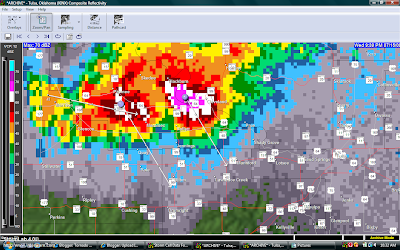
Below is a radar shot around 9:39pm (cdt) This cell had a 70dbz core with 3.5 in hail and reported winds above 60 mph. The NWS in Tulsa did had a severe thunderstorm warning on this storm but did not have any tornado warnings or the like. Interestingly enough, the above picture shows a classic wall cloud and small funnel. I took the picture looking west northwest towards the Cleveland OK area.

With a southeast movement, (as with most storms that move southeast) the wall cloud and any interesting features are usually on the west/southwest or northwest side of the storm. Generally the best viewing on a storm like this is usually from the south or southwest side which is exactly where I was located when I took the pictures. I am not sure why Tulsa NWS did not have a Tornado warning on this storm. Although not posted (because I did not save the SRV file to my hard drive) this storm had a a very strong couplet with nearly 100kts gate to gate! Clearly this storm, in my opinion, should have been tornado warned!!!
The rotating wall cloud was present for well over 30 minutes and I personally viewed it cycle 3-4 times. Using my ham radio, I did report the first wall cloud and funnel to the NWS.....
So why was a tornado warning not issued? That's a very good question and one that I don't have any kind of an answer for.
I have seen storms that clearly were not as severe as this that have and were tornado warned. Was someone asleep? Did someone not look at the velocity returns?
Chances are we will never know but, this is a perfect example of how a storm can be a possible tornado producer and not be tornado warned.
Not long after I took the picture, the storm moved a little to the south and reports of very large hail started coming in from north of Jennings. That's the direction I shot the picture below:

As you can see the storm still had a very large wall cloud and from the radar shot below you can even see a TVS ( Tornado Vortex Signature)

A tornado vortex signature, or tornadic vortex signature, (TVS), is a Doppler weather radar detected rotation algorithm that indicates the likely presence of a strong mesocyclone that is in some stage of the process of tornadogenesis. It gives meteorologists the ability to pinpoint and track the exact location of a tornadic rotation within a larger storm, and is an important feature in the National Weather Service's switch from county-sized tornado warning boxes to more focused fan-shaped warning zones.
It is often visible on the Doppler radar storm relative velocity product as side by side inbound and outbound velocities, a condition known as a velocity couplet or "gate-to-gate" shear. In most cases, the TVS is a strong mesocyclone aloft, not an actual tornado, although the presence of an actual tornado on the ground can occasionally be inferred based on a strong couplet in concert with a debris cloud signature. When the algorithm is tripped, a TVS icon and pertinent information appear. Radar analysis of the velocity couplet as well as the automated TVS are very significant to issuing tornado warnings and can suggest the strength and location of possible tornadoes. Although many tornadoes, especially the stronger ones, coincide with a TVS, many weak EF0-1 tornadoes can and do occur without a TVS, especially if they are not produced from an identified mesocyclone.
In my opinion and for what it's worth, a tornado warning should have been issued.
Where were you Tulsa?


1 comment:
Nice catch, I dimissed it as scud but my vantage point was too far away as I was at the north end of the Keystone Dam.
http://www.youtube.com/watch?v=UR2oMpTD1AI&feature=channel_page
Post a Comment